


Oscar Schofield, chair Department of Marine and Coastal Sciences (principal investigator) and Michael Crowley, MARACOOS technical director are working with the Mid-Atlantic Regional Association Coastal Ocean Observing System (MARACOOS) on a $1,542,076 cooperative agreement funded through NOAA to collect unique ocean and coastal data that is transformed into information products that support jobs, the economy, safety and well-being for the more than 78 million people living, visiting, and working in the Mid-Atlantic region.
MARACOOS is the Mid-Atlantic Regional Association Coastal Ocean Observing System, covering the region from Cape Cod, MA to Cape Hatteras, NC for NOAA’s U.S. Integrated Ocean Observing System. MARACOOS is a regional association of partners that supports the resiliency, security, safety, and health of Mid-Atlantic people and ecosystems.
The core funding for Rutgers encompasses key initiatives and the support for Michael Crowley as the MARACOOS technical director of the project, overseeing all data acquisition, quality control and distribution. The projects comprise four venues for data collection:
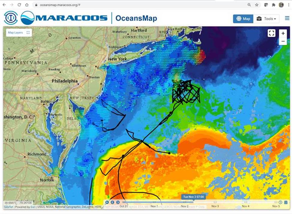
HF-Radar (CODAR): High Frequency (HF) Radar is used by ocean researchers to measure surface current velocity fields and waves over the coastal ocean and is used by ocean researchers to measure the speed of ocean surface currents. These land-based stations report currents every hour and have practical uses such as reducing search and rescue area for the US Coast Guard and helping emergency managers respond to oil spills and harmful algal blooms. During the last two years, the National Weather Service out of Mount Holly, NJ has begun using data from the HF-Radars to estimate wave heights just off the New Jersey coast.
Underwater Gliders: Autonomous Underwater Vehicles such as gliders are like underwater drones that adjust their buoyancy to dive and climb in a saw-tooth pattern. Gliders can be outfitted with a variety of sensors and are a low-cost solution to collecting many types of data including temperature, salinity, oxygen, currents, pH, chlorophyll, sediment load, animal/fish tracking and whale calls.
Satellite Data: MARACOOS receives satellite data from the NOAA, NASA and EUMETSAT (Europe) agencies. The global operational weather satellite system is composed of two types of satellites: geostationary operational environmental satellites (GOES) for short-range warning and “now-casting” and polar-orbiting satellites for longer-term forecasting. Both types of satellite are necessary for providing a complete global ocean and atmospheric weather monitoring system.
Ocean Modeling: MARACOOS serves dozens of products from ocean and atmospheric mathematical prediction models. All models rely on observations from scientific instruments in order to make their predictions—therefore it is imperative that the observations be of high quality—hence the need for data coming through MARACOOS to be government-certified. The science data can also be used to validate the accuracy of past model predictions, leading to paths forward for testing and improving model accuracy. Typical products include: coastal flooding & storm surge; currents; salinity; temperature; waves.
Additionally, the funding covers Rutgers directed projects that address data evaluation and support and performance of existing forecast systems. These include:
Integrated Ocean Observing System Underwater Glider Data Assembly Center (DAC): The mission of the Glider DAC is to provide glider operators with a simple process for submitting glider data sets to a centralized location, enabling the data to be visualized, analyzed, widely distributed via existing web services and the Global Telecommunications System (GTS) and archived at the National Centers for Environmental Information (NCEI).
Glider Data to Model Comparisons: IOOS science teams have continued to evaluate NOAA and Navy operational ocean modeling systems that support coupled hurricane forecasts. With the transition of data assimilation responsibilities to NOAA EMC and the use of the Real-time Ocean Forecasting System (RTOFS) as the new initial conditions for the HWRF, HMON, and experimental versions of HAFS, this work is of critical importance.
NOAA/NOS is also providing funds to the Rutgers University Ocean Modeling Group (RU OMG) for community support for NOS priorities of the Regional Ocean Modeling System (ROMS). Requested tasks will help ensure continuous operations and optimum performance of the existing suite of ROMS-based operational forecast systems, support community development of new algorithms, integration of community developed algorithms and capabilities into the ROMS code base and overall management of the operational ROMS code base, and deliver the enhancements necessary for the ROMS community code to meet the requirements of NOAA’s Unified Forecasting System.
This article was originally published by the SEBS/NJAES Newsroom on November 11, 2021